Short reports
Anak Krakatau August 2019
In August 2019 Anke from GRV travelled to Indonesia into the Krakatoa caldera and then to the Kelut for scientific studies. From 15 until 17 August 2019 she staid with a small international expedition group, organized by Volcano Discovery, in the Krakatoa caldera to study the huge changes after the partial collapse of Anak Krakatau in December 2018. Here is an excerpt from her report:
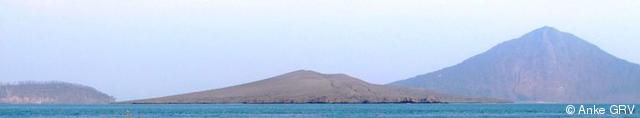
Anak Krakatau in August 2019
view from Sertung: Panjang (left), Anak Krakatau (in the midle) and Rakata (right)
It was very impressive to see the changes of Anak Krakatau on site. The underwater landslide and the following collapse of the volcanic cone in December 2018, probably caused by violent explosions in October and December 2018, has shrunk “the child of Krakatau”: The height above sea level was reduced from 338 to 110 meters and Anak lost about three-quarters of its subaerial volume. The landslide masses slipping into the Krakatoa caldera caused a catastrophic tsunami hitting the west coast of Java and the south coast of Sumatra (429 dead and 1485 injured). Rakata, Sertung and Panjang, the outer islands of the Krakatoa archipelago, also have been partly changed by the violent eruptions and the tsunami.
On 16.08.2019 we entered Anak Krakatau and climbed from the northeast side over ash fields and a canyon landscape created by erosion to the upper crater rim of the so much changed island. From there we observed the impressive steaming crater lake. In the middle of the crater lake darker areas were visible. A more detailed evaluation of the photograhic material later showed that in the middle part of the crater lake seems to be less water: Soil with a cracky structure similar to floes were visible.
 Canyons created by erosion |
 View from the upper rim on the crater lake |
After the observations from the upper rim, we entered Anak once more, namely from the crater side open to the sea, because I wanted to carry out temperature measurements in this area. Our boat stopped in front of the crater open to the seaside and Stefan and me after having waded the 38,8° warm water, brownish-tinted because of the iron compounds, approached the small “beach section”. Then we cautiously moved on this recently created area towards the shore of the crater lake - always in danger of unpredictible phreatic eruptions.
The soil in this area was rather hot (soil temperature: partly 68°C at a depth of 4cm), partly muddy, covered with tephra and in some places with sulfur deposits. It was a little bit alarming to see some clearly visible long fissures in the soil, these were no harmless dry cracks!
 |
The crater open to the sea |
I measured the temperature of the crater lake: It was between 61°C and 62°C at the edge of the lake, but might be higher in other places of the lake (probably about 80°C). The ph-value measured by Stefan was between 0,2 and 1.
 |
The shore of the crater lake |
ome days after our stay at the crater lake, several phreatic eruptions occurred. I therefore warn approaching the shore of the crater lake. We have approximated the crater lake taking into account the evaluation of the current seismic events and a observation from the upper rim, but Anak Krakatau remains a dangerous, explosive and unpredictable volcano. From the morphological point of view Anak Krakatau has returned to the situation in 1950. The lava flow that we witnessed during a violent eruptive phase in 2012 and that had slightly increased the area of the island (see our short report from September 2012) has disappeared since the events in December 2018.
 |
Photo: Stefan Tommasini http://vulkane-und-natur.de |
I thank Volcano Discovery and our guide Andi for the excellent organisation
of this impressive expedition!
Anke
Tambora-Caldera October 2017
In October 2017 we succeeded for the third time in descending into the fascinating Tambora caldera to the caldera floor. Like in the past we used the difficult and dangerous descent on the southern flank. Some steep walls could only be overcome with a rope. Due to the rainfalls in the past weeks, the canyons on the inner flank were partly washed out and very deep. Besides, it was also difficult to overcome some large blocks of rock and last not least there were some landslides. Because of the dangers we warn expressly once more to descend to the caldera floor without appropriate equipment and without competent guides. Also staying on the caldera floor can be dangerous: During this expedition we could only stay for a short time (one day, one night) on the caldera floor because of high gas concentrations. The night we spent there was not so relaxing because of some heavy rainfalls and a thunderstorm. Although we couldn’t realize all planned investigations because of the high gas concentration, it was a very interesting and informative expedition because the conditions were so different in comparison with the previous expeditions to the caldera floor.
We sincerely thank the reliable Indonesian helper team, without whom this expedition would not have been possible.
 |
The caldera floor of the Tambora October 2017, Georesearch Volcanedo Germany |
Tambora-Caldera August 2017
This year the lake (Moti La Halo) on the caldera floor was larger than in the past years resulting from the sometimes heavy rainfalls which lasted into August.
 |
 Moti La Halo, August 2017 |
Ascent of Mount Tambora in August 2015 on Zollinger’s way – 200 years after the big eruption
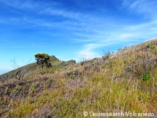
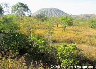 Ascent through the dry savanna,view to the north on the Doro Tabeh Naë |
 Ascent through the dry savanna, view to the east |
The aim of this year’s new expedition to the Tambora was the ascent from the east coast of the Sanggar peninsula over the east flank to the eastern rim of the caldera. The team of Georesearch Volcanedo (GRV) followed the way used by Zollinger as the first climber in 1847 after the big eruption and explored this way for the first time since 1847; because of the length of the distance to be travelled on foot, the partly very high temperatures and the lack of water it’s a particular challenge! As besides there were no exact geographic coordinates of the ascent, only the descriptions and the historical hand-drawn map of Heinrich Zollinger could be used to find the way. Starting on the east coast of the Sanggar peninsula up to the eastern rim of the caldera Zollinger’s stages could be realized very well. It was very interesting to examine the similarities, but also the changes in the landscape in comparison with Zollinger’s report. As our native helper team and we did not follow a common way, there were a lot of difficulties because of the area, about which Zollinger reported as well. In the end Zollinger as well as we could overcome these difficulties.
We would like to appreciate Zollinger’s achievement!
A current comparison with Zollinger’s description is in work.
 |
Only a few steep
meters to the eastern rim (2346 m)! 7 August 2015, Georesearch Volcanedo Germany |
Tambora caldera July/August 2014
12 days of research in the Tambora caldera – a new record!In July/August 2014 the research in the Tambora caldera was continued and
deepened. The results will be published at a later date in other media.
The descent to the caldera floor was again carried out on the very
difficult and dangerous inner southern flank. Besides, there were more
earthquakes which caused significantly more landslides.
 In the fore-ground one of the installed measuring stations on the caldera floor |
 Gases escaping under high pressure near the northern wall |
Note:
The by the team of GRV and his native helpers tested and explored descent on
the southern flank to the caldera floor between 2012 to 2014 was used again
after our descent in August 2014 by a few people. Currently the way seems to be
the only possible descent on the southern flank. Another descent at the
southern flanc that should have been used once in the past can not longer be
used due to landslides of the caldera wall. Nevertheless, because of the
dangers mentioned in our short reports, we would like to warn expressly to
descend without appropriate equipment and without competent guides which know
the terrain.
Tambora caldera (Indonesia) October 2013
 The Tambora caldera (Oct. 2013) |
 Descent on the inner southern flank |
Volcano research under extreme conditions in the Tambora Caldera (Indonesia), short report on an expedition into one of the deepest calderas in the world
The eruption of Tambora (located on Sumbawa) in April 1815 was the largest volcanic event since the beginning of recorded history and has become well known due to the global climate changes.
The aim of our expedition was the large caldera of the Tambora formed in 1815. This about 1300m deep giant volcanic hole is considered as the deepest caldera in the world since one after christ. In 2012 we had already carried out a preliminary expedition to the southern inner flank of this volcano.

In October 2013 we succeeded under the leadership of Arne C. as the first
German research team (GRV) in penetrating to the floor of the caldera where an
ecosystem has developped largely uninfluenced by anthropogenic factors. The
descent took place on the geologically very interesting inner southern flank
from 2430m to 1340m altitude.
To the team also belonged the geoscientist Anke D.-R. who was the first European
woman and worldwide the first woman conquering the almost impassable inner
southern flank of this volcano.
So far only in a few cases people had reached the caldera floor because
the terrain is difficult and extremely steep walls must
be overcome. Moreover, these people could only stay on the caldera floor for a
short time due to the enormous logistical problems. Therefore extensive
scientific studies were almost impossible.
The descent into this fascinating caldera of this active stratovolcano was
carried out with the help of a native team, elaborate logistics and the use
of climbing techniques.
During the stay on the caldera floor cartographical work was performed
(including the visible effects of the smaller eruptions which had taken
place on the caldera floor since 1815), rock and water samples were collected,
gas emissions were measured (gas and temperature measurements) and the flora
and fauna of this ecosystem were examined. A weather station built on the
caldera floor continuously recorded the weather data during our stay.
Beside numerous interesting studies the relatively high activity of Doro
Api Toi (strong fumarole activity, high temperatures) and the gases escaping
under high pressure on the lower north-east wall were particularly striking.
The Doro Api Toi is a small volcanic cone formed in the southern part of the
caldera floor about 1880.
Besides we discovered near the Doro Api Toi a lavadome which had not yet
been mentioned in scientifical studies. We called this new discovery
“Adik Api Toi” (Indonesian “adik”: younger brother).
Later this lavadome was officially discovered by the Indonesian side and
was called “Doro Api Bou” (“new volcano”).This
lavadome probably appeared in 2011/2012 when there was an increased seismic
activity and probably on the caldera floor volcanic activity (there is no
exact information about the caldera floor at that time).
Despite various hazards (landslides, debris flows, gas emissions) and difficult
working conditions such as extremely high temperatures the team was able to
achieve fundamental results for further research and to create a comprehensive
illustrative documentation.
The stay within the Tambora caldera including the research of the caldera
floor lastened nine days and is until now unique.
 View from the caldera floor on the north wall |
 Preparation of gas measurements on the caldera floor on the south wall |
Violent eruptive phase of Anak Krakatau on 2 and 3 Sept 2012
 Anak Krakatau, 3.9.2012 |
 Excerpts from the seismic records of this event (Krakatau observatory) |
On 3 September 2012 we were able to observe at close range the violent explosive eruptions of Anak Krakatau. These were the strongest eruptions of Anak Krakatau which had been observed since 1996 (see Monthly Reports of the Smithsonian Institution). We had witnessed several eruptions of Anak Krakatau in the last years, but that eruption in early September exceeded all of what we had observed up to then. Between 10 am and 4 pm explosions like a gunfire took place without interruption.The eruption column partially reached a height of about two kilometers. The scenery was all the more impressive because lava flows entering the water led to a strong formation of steam and also to phreatomagmatic explosions with ash formation.
The information on this event spread in the Indonesian media were by the way sometimes not precise. Thus, the severity of the eruption may have been downplayed so as not to alarm the population on the west coast of Java who had been afraid because of the thunderclap-like noise and ground vibrations emanating from Anak Krakatau in the night of 2 to 3 September. We also felt significant vibrations in the soil at Carita during that night.
Even in the late afternoon of 3 September, we were the first science team stepping on Anak Krakatau during this eruptive phase with our companion Aris and other helpers. At that moment the volcano had reached a rather strombolian activity.
Until 6 September we made investigations on the volcanic island of Anak Krakatau. The 4 September we visited the summit region and the origin of the lava flow entering the water in the southeast. The volcano had become quiet now, so we dared to climb up. The climb sometimes turned out to be a little bit hard because of the fresh volcanic ash.
On 5 September at 11am a strong degassing began (we measured high SO2 and H2 values). This degassing continued until our departure on the morning of 6 September.
More detailed results of that “volcanic highlight” of the year 2012 will be published in another place at a later date.
 Anak Krakatau, 3.9.2012 |
 At the new lava flow on Anak Krakatau on 4 September (at 5.50 in the morning). The new lava flow has a total length of approximately 600m, it extends into the water about 100m. The “Child of Krakatoa” has thus grown in width! |
All the photos and texts are the property of Georesearch Volcanedo.